
Campsies fell activitySat 11 Mar, 2023
Glengoyne
Local level event
Explanation of Event levels
Local events are usually low key and in the 'localised' area, ideal for newcomers to try the sport and Training events are non competitive and used for training and coaching, aimed at members of the club, but they can attract people from neighbouring clubs, and are often ideal for newcomers to try the sport. Regional events attract participants from around the local Region, National events are high quality competitions that will attract people from far away, Major events are Major Events such as a British Championships.
Terrain type: Moorland
Overview
Glasgow Uni Orienteers and Trailrunners, in collaboration with Clydeside Orienteers, present an unmissable fell activity in the Campsies/Glengoyne – resilience, navigation and strength will truly be put to the test!
Location Info
/-4.316,55.9879,12/500x400?access_token=pk.eyJ1IjoicGF1bGZyb3N0IiwiYSI6ImNrb3dtYXoycjA2NGMyeHQ2bmRqMnFrZjIifQ.nP5lTcgIDEirGf32roluZg)
Near: Blanefield Lat,Lng: 55.9879,-4.316 OS Grid Ref: NS556796 Postcode: G63 9HZ What3Words: ///storming.swelling.clotting
Open an interactive map in:
GoogleMap -
OpenStreetMap -
BingMap (OS 50k)
Directions / Parking
Start is at the start of the private road (Campsie Dene Road also referred to as the “pipetrack road”) near St Kessog’s church in Blanefield. Parking is available in the parking place of St. Kessog’s or on the streets in the area. The start can be reached by public transport using bus X10A (stop: Blane Valley Inn) followed by a 1-minute walk.
Map / Terrain
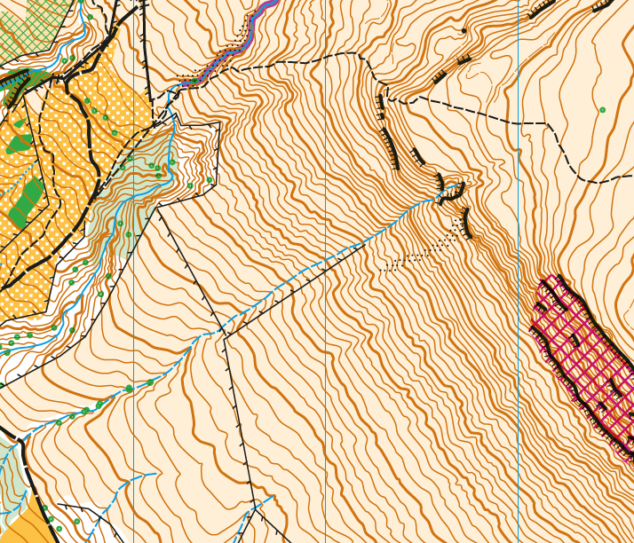
1:10,000 map ISOM 2017-2 of the west side of the Campsie Fells by Klaas Wynne, last update February 2023. Uses 5m contours and 2.5m form lines.
Mixed moorland terrain: gravel/muddy trails, hills steep to very steep in places, cliffs are OOB, tussocky grass, deep heather, mud.
Course Information
- Short course, Length 9.2 km 790m climb - follows 90% trails, some relatively straightforward cross country, controls fairly obvious, head for heights required.
- Long course, Length 13.8 km 1100m climb - mostly off-trail and cross country, controls bit harder to find, head for heights essential for shortest route.
- Long-minus course, Length 10.2 km 920m climb - mostly off-trail and cross country, controls bit harder to find, head for heights essential for shortest route. This shorter version takes out a long leg to keep distance and vert a bit more manageable but is of same terrain difficulty as the Long.
Entry Details
Entry deadline Weds 8th March 10pm - enter via this googleform
Entry before noon on Friday 10 March: email klaas.wynne@glasgow.ac.uk direct.
Each event will be £2 for GOAT and Clyde members and £4 for non Clyde/GOAT members - payment details will be provided after entry
Registration and Start times
Start at 11 am - mass start. A sweeper will be used to ensure everybody comes back safely.
Contacts / Officials
Please contact Klaas Wynne, klaas.wynne@glasgow.ac.uk if you have any questions
Nearest A&E Hospital
Queen Elizabeth, 1345 Govan Rd, Glasgow G51 4TF.Safety Notes
As this is an open hillside environment, the requirements are: studded shoes, rain proof full body cover (taped seams), hat, and gloves. We recommend: a (waterproof) running pack, emergency foil bag, head torch, phone, food, drink, fleece, puffy, first aid.
Covid - please do not attend if you have Covid, or Covid symptoms.
Competitors are responsible for their own safety.
Children (u16s) must be accompanied by a responsible adult.
Any participants with relevant pre-existing medical conditions which might affect their participation should disclose them to the race organisers before they start.